Window of Archipelago

La Galigo - Similar to the Koran but older than the Koran

Ujungpandang ( Dreamland Library ) - The Bugis in South Sulawesi, adheres to a belief in the Gods of Seuwae (the Only God). "The Bug...

Showing posts with label 200 AD. Show all posts

Papua is a Paradise that fell to Earth

Tribel Natives
Papua (Dreamland Library) - Other names for Papua: LABADIOS, TUNGKI, JANGGI, PAPA-UA, NUEVA GUINEE, ISLA DEL ORO (Pulau Emas), HEAVENLY LOST HEAVEN

Papua is the second largest island in the world. Around the year 200 AD, a geographer named Ptolamy called it LABADIOS. At the end of 500 AD, the Chinese author Ghau Yu Kua gave the name TUNGKI, and at the end of 600 AD, the Srivijaya Kingdom mentioned the name Papua using the name JANGGI.

Tidore gave the name for this island and its inhabitants as PAPA-UA which has changed in the name to PAPUA. In 1545, Inigo Ortiz de Retes gave the name NUEVA GUINEE and there was another sailor who gave the name ISLA DEL ORO which means Gold Island. Robin Osborne in his book, Indonesias Secret War: The Guerilla Struggle in Irian Jaya (1985), dubbed Indonesia's easternmost province as HEAVEN HEAVENLY.

Back to Dreamland Library 7-Lifestyle - Back to 7-Lifestyle

It is unknown whether in ancient BC civilization there was a kingdom in Papua. It could be that ancient times there were advanced civilizations in Papua. At a conference on street lights and traffic in 1963 in Pretoria (South Africa), C.S. Downey said about an isolated settlement in the middle of the dense forest of the Wilhelmina Mountains (Peg. Trikora) in Western New Guinea (Papua) which has an advanced lighting system.

The traders who painstakingly managed to penetrate into this settlement told of his horror at the very bright lighting of the "several months" that were on the poles there. The bulbs seemed to glow strangely after the sun began to set and kept burning all night every day. We do not know the truth of this story but if it is true it is extraordinary and must be investigated.

Papua has been known for its natural wealth long ago. In the 18th century AD, the rulers of the Srivijaya empire, sent offerings to the Chinese empire. In the offering there are several birds of Paradise, which are believed to be Birds of the Garden of Heaven which are native animals from Papua.

Back to Dreamland Library 7-Lifestyle - Back to 7-Lifestyle

With its strong fleet Sriwijaya visited Maluku and Papua to trade in spices, fragrances, pearls and feathers of the Cenderawasih bird. During the Majapahit Kingdom a number of areas in Papua were included in the Majapahit territory. In the sixteenth century the North to West coast of the Bird's Head to Namatota (Kab. Fak-Fak) area in the south, and the surrounding islands became the territory of Sultan Tidore.

The land of Papua is very rich. Copper and gold are abundant natural resources found in Papua. Papua is famous for the largest gold production in the world and a variety of mines and natural resources are so abundant.

Papua is also touted as a Little Heaven Falls to Earth. Papua is the Paradise of Biodiversity Remaining on Earth Today. In 2006, a survey team consisting of American, Indonesian and Australian explorers conducted a survey in some of the mountainous regions of Foja, Papua Province of Indonesia.

There they found a magical place they called "The Lost World", and "Paradise Garden on Earth", by watching dozens of species of birds, butterflies, frogs and plants that have never been recorded in history. If managed properly, Papuans can prosper more with the abundant natural wealth.

Back to Dreamland Library 7-Lifestyle - Back to 7-Lifestyle

Source: http://ahmadsamantho.wordpress.com/2012/10/29/misteri-wow-struktur-mirip-tembok-lurus-di-dalam-laut-utara-papua/

Papua - Island of Paradise

Jakarta (Dreamland Library) - Papua is the second largest island in the world. Around the year 200 AD, a geographer named Ptolamy called it LABADIOS. At the end of 500 AD, the Chinese author Ghau Yu Kua gave the name TUNGKI, and at the end of 600 AD, the Srivijaya Kingdom mentioned the name Papua using the name JANGGI. Tidore gave the name for this island and its inhabitants as PAPA-UA which has changed in the name to PAPUA. In 1545, Inigo Ortiz de Retes gave the name NUEVA GUINEE and there was another sailor who gave the name ISLA DEL ORO which means Gold Island. Robin Osborne in his book, Indonesias Secret War: The Guerilla Struggle in Irian Jaya (1985), dubbed Indonesia's easternmost province a lost paradise.

It is unknown whether in ancient BC civilization there was a kingdom in Papua. It could be that ancient times there were advanced civilizations in Papua. At a conference on street lights and traffic in 1963 in Pretoria (South Africa), C.S. Downey said about an isolated settlement in the middle of the dense forest of the Wilhelmina Mountains (Peg. Trikora) in Western New Guinea (Papua) which has an advanced lighting system. The traders who painstakingly managed to penetrate into this settlement told of his horror at the very bright lighting of several months on the poles there. The bulbs seemed to glow strangely after the sun began to set and kept burning all night every day. We do not know the truth of this story but if it is true it is extraordinary and must be investigated.

Papua has been known for its natural wealth long ago. In the 18th century AD, the rulers of the Srivijaya empire, sent offerings to the Chinese empire. In the offering there are several birds of Paradise, which are believed to be birds from the garden of paradise which is native to Papua. With its strong fleet Sriwijaya visited Maluku and Papua to trade in spices, fragrances, pearls and feathers of the Cenderawasih bird. During the Majapahit Kingdom a number of areas in Papua were included in the Majapahit territory. In the sixteenth century the North to West coast of the Bird's Head to Namatota (Kab. Fak-Fak) area in the south, and the surrounding islands became the territory of Sultan Tidore.

The land of Papua is very rich. Copper and gold are abundant natural resources found in Papua. Papua is famous for the largest gold production in the world and a variety of mines and natural resources are so abundant. Papua is also touted as a small paradise that fell to earth. Papua is a haven of biodiversity left on earth today. In 2006, a survey team consisting of American, Indonesian and Australian explorers conducted a survey in some of the mountainous regions of Foja, Papua Province of Indonesia. There they found a magical place they called "the lost world", and "Paradise Garden on earth", by watching dozens of species of birds, butterflies, frogs and plants that have never been recorded in history. If managed properly, Papuans can prosper more with the abundant natural wealth.

Thus a little writing about the islands in Indonesia which is very rich. From these writings, in fact Indonesia has been known as a rich earth since ancient civilization. We do not know what ancient civilizations actually existed in this archipelago. It could be that there has been an ancient and prosperous civilization in Indonesia that is not recorded in history.

Brazilian Scientist Prof. Dr. Aryso Santos, confirmed the theory that Atlantis was the area now called Indonesia. Indonesia is a region considered to be Atlantis's heir. Plato mentioned that Atlantis was a prosperous country bathed in sun all the time.

Oppenheimer in the book "Eden in the East: the Drowned Continent of Southeast Asia", proposes that Sundaland (Indonesia) is the Garden of Eden (Garden of Eden). that the Garden of Eden (Eden) was not in the Middle East, but rather in Sundaland. Indonesia is indeed a fertile and beautiful land located in the ring of fire (pacific ring of fire), which is marked by the presence of more than 500 volcanoes in Indonesia. Indonesia could be called a paradise surrounded by a ring of fire. But regardless of whether or not we all agree to say that in fact Indonesia is a country that is very rich in agricultural products, sea and culture.

The original culture of Indonesia was thousands of years before the civilizations of Egypt and Mesopotamia began writing on stone. Indonesian civilization might not have started with a written tradition, but the oral tradition has lived and rooted in the souls of our nation's ancient society.

Indonesia's rich and well-nurtured nature by our ancestors is also one of the factors that makes the archipelago a source of worldwide attention. Indonesia is a country located on the equator that has abundant natural resource wealth in addition to its strategic geographical location. These natural resources ranging from marine resources, forests, to mining goods spread from Sabang to Merauke. Now many new mines have been discovered in Indonesia. Indonesians will be surprised at what other natural wealth will emerge from this Indonesian earth.

This rich earth, if managed properly, will make every Indonesian people able to obtain extraordinary prosperity so that one day the people of Indonesia may not need to be taxed as it is now, and all facilities can be enjoyed free of charge thanks to the abundant natural wealth that is shared to the people fairly. What Indonesia needs is a good, fair and smart ruler who loves the people very much and rejects all kinds of policies which make it difficult for the people. It is time for Indonesia to rise to its former glory. If that happens Indonesia can become the richest country in the world.

Source: 
http://blognyajose.blogspot.com/2010/02/pulau-pulau-indonesia-yang-sangat-kaya.html

Copied from: 
http://terselubung.blogspot.com/2010/08/pulau-pulau-indonesia-yang-sangat-kaya.html

Photo: Special

Batujaya Temple - Year 200 AD

The originator of "Dream Land Library" has a Temple of Soul background
Bekasi (DreamLandLibraty) - In the Batujaya site area there are relics from the classical period. The Batujaya region covers a fairly wide area of ​​around 5 km2, spanning the coordinates of 06 ° 02'52.10 "- 06 ° 03'34.17" South Latitude and 107 ° 09'01.00 "- 107 ° 09'05, 91 "East Longitude.

Administratively this area is included in the area of ​​Segaran Village, Batujaya District and Telagajaya Village, Pakisjaya District. The site is not far from the northern coastline of the Java Sea, in paddy fields and partly in residential areas. To the south of the site is the Citarum River. Rivers and rice fields never experience dry periods. During the year it was wet with puddles and infiltration water.

Research in the Batujaya site area began in 1975-1976 in the form of exploratory research. Furthermore, in 1984 research was conducted (excavation) by the Department of Archeology, Faculty of Letters, University of Indonesia (FSUI). Since then, more intensive research has been carried out by various institutions including FS UI, the National Archeology Research Center (Puslit Arkenas), the Directorate for the Protection and Development of Historical Heritage (Ditlinbinjarah (, Tarumanagara University (Untar), the National Survey and Mapping Agency (BAKOSURTANAL) ), and the Bandung Archeology Center (Balar).

Archaeological remains in Batujaya until the year 2000 have found 24 sites scattered in the villages of Segaran and Telagajaya. In the village of Segaran found 13 sites and 11 sites in Telagajaya. Of the 24 sites, there are several sites that have been excavated and reveal the remaining temple buildings.

The mound in which the ancient brick ruins of the people call it the term 'unur'. These sites include Segaran I (SEG I or Unur Jiwa), Segaran III (SEG III or Unur Damar), Segaran IV (SEG IV), Segaran V (SEG V or Unur Blandongan), Segaran IX (SEG IX or Pool Site) , Telagajaya I (TLJ I or Unur Shaved), Telagajaya V (TLJ V or Unur Asem), and Telagajaya VIII (TLJ VIII).

Unur Jiwa has been completely excavated and restoration has begun from 1997 to 2004. This site is located at coordinates 06 ° 03 '427 "South Latitude and 107 ° 09' 287" East Longitude. The temple building is only a leg part and a little part of the rest of the body of the temple. Rectangle temple building measuring 19x19 m. The height of the remaining part is 4.7 m.

Building orientation to the southeast - northwest. Because no stairs or entrances were found, the direction of the attack was unknown. At the top of the building there is a brick structure that forms a square and concentric circular arrangement of bricks that resembles lotus flower petals.

The building at Unur Jiwa is now completely restored. On the signboard located at that location is called the Soul Temple. With the completion of the restoration it appears that the foot profile consists of flat seams (patta), buffer seams (uttara), and semicircular seams (kumuda).

Brick joints on the legs show the use of a thin white adhesive layer. This layer is usually called stuco. On the surface of the brick there is also a layer that still leaves stuco. Based on such traces it is thought that the walls of the building were covered with stuco.

At the top there is a circular brick structure about 6 m in diameter. This section may be the basis of a stupa or pedestal on a terrace. The amazing part is also found on the upper surface, namely on the sides are made wavy so that it gives the impression of a lotus flower petals that are blooming.

In Unur Damar (SEG III) there is a remnant of the building in the form of the foot of a rectangular temple with a size of 20 X 15 m. On the northwest side there are parts of the stairs that the condition is already sunk. At the SEG IV site there is also a remnant of a rectangular building measuring 6.5 X 6.5 m with a remaining height of 1 m. On the southeast side there is a structure that jutted out like the rest of the stairs.

Unur Blandongan (SEG VI) is a unit whose breadth is relatively the same as Unur Jiwa. This site is located at coordinates 06 ° 03 '351 "South Latitude and 107 ° 09' 203" East Longitude.

In Unur Blandongan there is a temple building with a square shape with a size of 25 X 25 m. On all four sides there are steps. At the bottom of the building there is a hallway (aisle) that separates the hallway wall with a tiled building body.

12 x 12 m building plinth. On this pedestal there is a building body measuring 10 X 10 m. Excavation on this site found a number of tablets with Buddhist reliefs. Some of them have written Pallawa letters. In addition, several scratched stones were also found. Unur Blandongan is now under renovation.

The building that looks at the SEG IX site is a rectangular shaped pool building with a size of 7.35 X 10.55 m. The average wall thickness is 1.7 m except the northeast side wall with a thickness of more than 4 m. The depth of the pool is unknown.

Unur Serut (TLJ I) is at coordinates 06 ° 03 '359 "South Latitude and 107 ° 09' 052" East Longitude. On this site there are four buildings. IA TLJ buildings have not been fully revealed. This building is in the form of a foot temple with a length of 22 m and 10 m wide.

The TLJ IB building is very damaged. From the rest there are estimated to have a square with 8.5 m in length.

TLJ IC building has a rectangular shape with 6 m side length.

On the northeast side there are stairs. The building is detached and decorated with ornaments made of lime cement (stucco). some decorations in the form of head of human and animal statues made from stucco are also found in the ruins on the outside of the foot of the temple building.

The yard around the building is likely to have experienced pengurugan. The surface of the yard is then covered with a layer of plaster from stucco material. The TLJ ID building is a pool. The remaining structure is an elongated wall that is angled at the bottom of a pond.

The building on the TLJ V (Unur Asem) site has a square size of 10 X 10 m. The temple is equipped with two stairs located on the southeast and northeast. The stairs on the southeast side are built later than the stairs on the northeast side. At the top of the rest of the building is a brick structure with a concentric circle.

Excavation at TLJ VIII site has revealed the remaining parts of the temple's foot rectangular shaped with a length of 6 m and a width of 4 m. On the northeast side of the stairs equipped. In the middle of this building there is a well with a size of 1.80 X 1.75 m.
Based on the shape of the building and some existing archeological remains, it can be ascertained that the temple building in the Batujaya area is set on the Buddha. The Batujaya site area is thought to be related to the Tarumanegara Kingdom. Analysis of C14 shows the oldest age from the 2nd century and the youngest of the 12th century. Foreign ceramics found show ceramics produced from the 9th-14th century AD

Several ruins of the temple building are now under renovation. The Soul Temple was the first to be restored. At the moment the restoration process is the Blandongan Temple. Several other temples are still under research.

Because each temple is separated from a rice field, a 1 m wide walkway was built connecting the Soul Temple and Blandongan. To go to the other temples, you can pass the rice field road.

Source: http://www.disparbud.jabarprov.go.id


Photo: Dream Land Dock

Similar Structure "Wall" Straight in the North Sea of ​​Papua

Main Literacy
Manado (DreamLandLibrary) - ENTAH WHY, SUDDENLY GOOGLEMAP ELIMINATES THE STRUCTURE SINCE JANUARY 2012 THEN

For the Indonesian people, Nuswantara (Nusantara) is also known to cover the land of Irian Jaya (the island of Papua). One of the largest islands in the world contains many mysteries that have not been revealed.

It turns out that in the northern waters of one of the largest islands is also stored an amazing mystery!

When the Earth was in the ice age thousands of years ago, the island of Irian was much bigger. The southern part is still connected with the Australian continent.

Likewise in the northern coast of the island of Papua, the land is broader than it is now. Its land is still far stretching to the middle of the sea hundreds of kilometers because the sea level at that time was still shallower than at present.

Sea level that is still shallow or still low is due to the ice spread region at the north and south poles which have not melted much like now.

Off the coast of the northern part of this large island, it is estimated that there are building structures similar to "beteng" (lay: fortress) whose length is 110 km and the height is as high as a mountain: 1860 meters, with a width of 2700 meters!

When seen, this structure is more like a "wall" or "wall". And amazingly again this wall perfectly extends perfectly 110 kilometers long!

If true, it is clearly beteng like this could not have been made by ape or primitive human civilization, given the tallest building in the modern age alone, the height is only about 800 meters, the Dubai tower. While this building has risen 1860 meters or more than 2 times the height of Dubai Tower!

This building could not have been built by people who were only armed with chopsticks, swords, krisses and spears, and also could not have been built by people whose means of transportation were limited to donkeys, horses and carts.

The structure is located offshore not far from the largest city and also the capital of Papua, Jayapura. Therefore the structure is temporarily called Jayapura Wall or Jayapura Wall.

Using Google Maps, the amazing coordinates of the Beteng are seen in the Pacific Ocean, which is in the northern part of the island of Papua (Irian Jaya) at 1 ° 59 '46.9 "S and 141 ° 29 '24.6239" E (see via satellite)

Main Literacy

Source: http://ahmadsamantho.wordpress.com/2012/10/29/misteri-wow-struktur-mirip-tembok-lurus-di-dalam-laut-utara-papua/
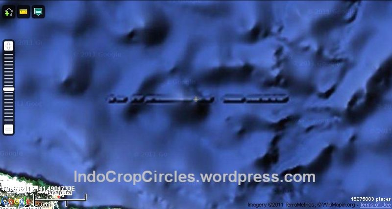
Photo: Special

Similar Structure "Wall" Straight in the North Sea of ​​Papua


Off the coast of the northern part of this large island, it is estimated that there are building structures similar to "beteng" (lay: fortress) whose length is 110 km and the height is as high as a mountain: 1860 meters, with a width of 2700 meters!

WHY IS IT WHY, GOOGLEMAP SUDDENLY ELIMINATES THE STRUCTURE SINCE JANUARY 2012 THEN

For the Indonesian people, Nuswantara (Nusantara) is also known to cover the land of Irian Jaya (the island of Papua). One of the largest islands in the world contains many mysteries that have not been revealed.

It turns out that in the northern waters of one of the largest islands is also stored an amazing mystery!

When the Earth was in the ice age thousands of years ago, the island of Irian was much bigger. The southern part is still connected with the Australian continent.

Likewise in the northern coast of the island of Papua, the land is broader than it is now. Its land is still far stretching to the middle of the sea hundreds of kilometers because the sea level at that time was still shallower than at present.

Sea level that is still shallow or still low is due to the ice spread region at the north and south poles which have not melted much like now.

When seen, this structure is more like a "wall" or "wall". And amazingly again this wall perfectly extends perfectly 110 kilometers long!

If true, it is clearly beteng like this could not have been made by ape or primitive human civilization, given the tallest building in the modern age alone, the height is only about 800 meters, the Dubai tower. While this building has risen 1860 meters or more than 2 times the height of Dubai Tower!

This building could not have been built by people who were only armed with chopsticks, swords, krisses and spears, and also could not have been built by people whose means of transportation were limited to donkeys, horses and carts.

The structure is located offshore not far from the largest city and also the capital of Papua, Jayapura. Therefore the structure is temporarily called Jayapura Wall or Jayapura Wall.

Using Google Maps, the amazing coordinates of the Beteng are seen in the Pacific Ocean, which is in the northern part of the island of Papua (Irian Jaya) at 1 ° 59 '46.9 "S and 141 ° 29 '24.6239" E (see via satellite)


Source : http://ahmadsamantho.wordpress.com/2012/10/29/misteri-wow-struktur-mirip-tembok-lurus-di-dalam-laut-utara-papua/

200 AD and Beyond

Jakarta (DreamLandLibrary) - In the search for the Dream Land Team, we still provide a timeline


We believe this year's poultices, have a lot of history of our Nation .....

3rd Century or 200 AD to 299 AD
In 200 AD the construction of the Batujaya Temple

Salakanagara - 130 AD

Pandeglang (Dreamland Library) - Salakanagara, based on Wangsakerta Manuscript - Rajyarajya i Bhumi Nusantara Library (which was organized by a committee with its chairman Prince Wangsakerta) is thought to be the earliest kingdom in the archipelago.

The names of experts and historians who prove that the Banten Tatars have high historical values ​​include Husein Djajadiningrat, Tb. H. Achmad, Hasan Mu'arif Ambary, Halwany Michrob and others.

Many of their findings have been compiled in writings, reviews and in books. Not to mention names like John Miksic, Takashi, Atja, Saleh Danasasmita, Yoseph Iskandar, Claude Guillot, Ayatrohaedi, Wishnu Handoko and others who added insight about Banten to become more extensive and open with his works made both in Indonesian and English.

Indian ancestry
The founder of Salakanagara, Dewawarman was a traveling ambassador, merchant and immigrant from Pallawa, Bharata (India) who eventually settled because he married a local prince, while Tarumanagara's founder was Maharesi Jayasingawarman, a refugee from the Calankayana region, Bharata because his territory was controlled by another kingdom. While Kutai was founded by refugees from Magada, Bharata after the area was also controlled by another kingdom.

The initial figure in power here was Aki Tirem. That said, this city was called Argyre by Ptolemy in 150, located in the Lada Pandeglang Bay area. It was Aki Tirem, the ruler or ruler of the local village that eventually became Dewawarman's father-in-law when the daughter of Sang Aki Luhur Mulya named Dewi Pwahaci Larasati was married to Dewawarman. This made all of Dewawarman's followers and troops married to local women and did not want to return to his hometown.

When Aki Tirem died, Dewawarman received a scepter. In 130 AD he then founded an empire named Salakanagara (Silver Country) with a capital in Rajatapura. He became the first king with the title Prabu Darmalokapala Dewawarman Aji Raksa Sagura Gapura. Several small kingdoms around him became his territory, including the Kingdom of Agnynusa (Land of Fire) on Krakatau Island.

Rajatapura is the capital of Salakanagara which until 362 was the seat of the government of the Kings of Dewawarman (from Dewawarman I - VIII). Salakanagara stood only for 232 years, precisely from 130 AD to 362 AD. King Dewawarman I himself only ruled for 38 years and was replaced by his son who became King Dewawarman II with the title Prabu Digwijayakasa Dewawarmanputra. Prabu Dharmawirya was listed as King Dewawarman VIII or the last king of Salakanagara until 363 because since then Salakanagara has become a kingdom under the authority of Tarumanagara which was founded in 358 AD by Maharesi who came from Calankayana, India named Jayasinghawarman. During the reign of Dewawarman VIII, the economic condition of the population was very good, prosperous and peaceful, while religious life was very harmonious.

While Jayasinghawarman, founder of Tarumanagara, was the son-in-law of King Dewawarman VIII. He himself was a Maharesi from Calankayana in India who fled to the archipelago because his area was attacked and conquered by Maharaja Samudragupta from the Maurya Kingdom.

Later on after Jayasinghawarman founded Tarumanagara, the seat of government shifted from Rajatapura to Tarumanagara. Salakanagara then changed to the Regional Kingdom.

Order of King Salakanagara


The list of names of the kings who ruled the Kingdom of Salakanagara are:
Tahun berkuasaNama rajaJulukanKeterangan
130-168 MDewawarman IPrabu Darmalokapala Aji Raksa Gapura SagaraPedagang asal Bharata (India)
168-195 MDewawarman IIPrabu Digwijayakasa DewawarmanputraPutera tertua Dewawarman I
195-238 MDewawarman IIIPrabu Singasagara BimayasawiryaPutera Dewawarman II
238-252 MDewawarman IVMenantu Dewawarman II, Raja Ujung Kulon
252-276 MDewawarman VMenantu Dewawarman IV
276-289 MMahisa Suramardini WarmandewiPuteri tertua Dewawarman IV & isteri Dewawarman V, karena Dewawarman V gugur melawan bajak laut
289-308 MDewawarman VISang Mokteng SamuderaPutera tertua Dewawarman V
308-340 MDewawarman VIIPrabu Bima Digwijaya SatyaganapatiPutera tertua Dewawarman VI
340-348 MSphatikarnawa WarmandewiPuteri sulung Dewawarman VII
348-362 MDewawarman VIIIPrabu Darmawirya DewawarmanCucu Dewawarman VI yang menikahi Sphatikarnawa, raja terakhir Salakanagara
Mulai 362 MDewawarman IXSalakanagara telah menjadi kerajaan bawahan Tarumanagara
ReferensE

    ^ Ayatrohaedi: Sundakala, Cuplikan Sejarah Sunda Berdasar Naskah-naskah "Panitia Wangsakerta" Cirebon. Pustaka Jaya, 2005.

Souce : http://id.wikipedia.org/wiki/Kerajaan_Salakanagara

Photo : Special

Arabic Culture Turns Inheritance from Christian Religious Culture